Please note that time limits apply. Events are typically not canceled due to bad weather.
By Dennis Wildfogel
Pilot Knob is a large, round, hill towering over Lake Lagunitas (which itself is the water source for Bon Tempe Lake). Our newly-mapped orienteering area is almost entirely on the slopes of this big hill. The Knob is flat at the top (with incredible views!), but getting up there is not for the faint of heart. The lower slopes are gentle, but as you ascend, it gets steeper — and then it gets really steep. In the Bay Area, we orienteers develop a mindset of never losing altitude if you can avoid it, but circling around this big round hill, you might want to consider dropping down to traverse, even if it means ascending at the end. Let the spacing of the contours tell you what to do.
Being mindful of the variation in the density of contour lines will be key. This a 1:5000 map — where the contour lines are close enough together to make you think it's steep there, it's really steep. (Note, too, that as you move through the terrain at 1:5,000, things come up a good deal more quickly than you're used to.)
There are several ways in which this competition area is not like other Bay Area venues, or even like the rest of Bon Tempe. The area is technical and subtle. You will want to focus on being your best navigational self.
There are long corridors of runnability. The courses are designed so that you can take advantage of those corridors — but you have to seek them out.
Hazards ↑
Do not step on logs! They are almost always damp and slippery. Stepping on one is good way to injure yourself seriously.
Recent mornings have been damp and chilly. Dress accordingly. Wear your grippiest shoes, as the ground cover can be slippery when damp. Stickers and burrs are gone. Nevertheless, I've been wearing gaiters to keep my feet and lower legs a bit warmer and drier.
The trail/road network in the competition area is very sparse. You will be experiencing parts of a deep, dark forest, where humans don't ordinarily go.
Courses ↑
The course details are here. (Note that a special "bonus course" has been added.)
The courses are technical right out of the Start. Be on high alert immediately.
Unlike most of our venues (including the rest of Bon Tempe), there is no appreciable undergrowth.
You'll almost certainly see controls you aren't going for. Don't just run to a bag if you see one.
The Silver through Red courses have a map flip. When you start, you'll get a map case with the first part of your course facing up, and with a second sheet facing the other way. The control that ends the first part and starts the second part is on both maps, and is also indicated on the clue sheet. Of course, you shouldn't look at your map at all until after you punch the Start unit. Furthermore, you should not look at the second part of your course until you actually see the bag for the flip control. After you turn over your map to start using the second part, you are not allowed to look back at the first part. Obviously, we can't enforce those "rules", but that's what playing by the rules would mean.
There is one water stop on each course (except the Mini and Custer's Choice).
Make sure you understand what the symbols in the legend below mean, and what those things look like in the terrain.
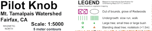
Map Legend
In particular, make sure you know both the clue sheet and map symbols for water hole and rootstock (i.e., upper and lower rows in the graphic below, respectively).
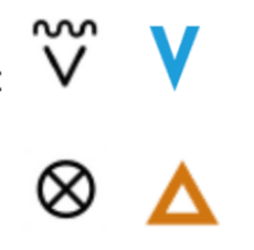
Water Hole & Rootstock Symbols
These photos are examples.
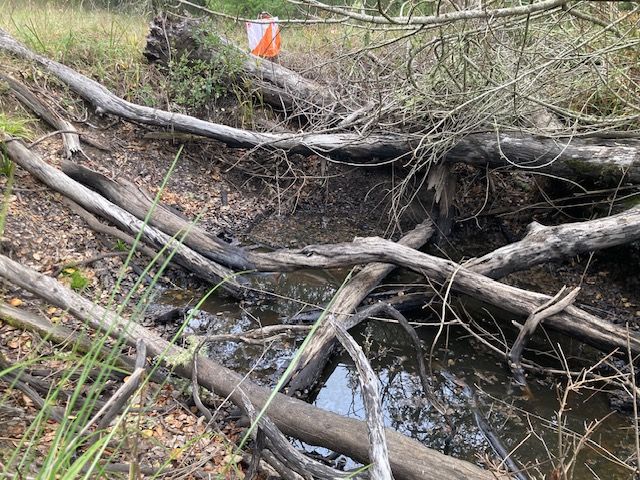
Water Hole
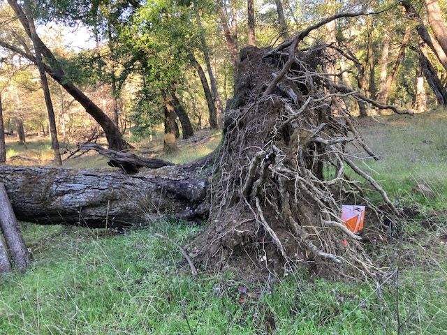
Rootstock
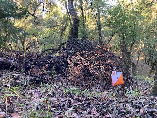
There are many downed trees, but that doesn't make them rootstocks. A rootstock is supposed to be a well-preserved root system of a fallen tree. For this map, a rootstock must be at least 1.5 meters high to be mapped. In areas where there are many fallen trees, but only one or two mapped rootstocks, it is not always easy to discern which one(s) are the mapped rootstocks without close inspection (and without a meter stick). On the other hand, all the rootstocks used as control locations are unmistakable.
Some small, dark or medium-green patches on the map are not densely packed bushes, but rather tangles of dead branches of one or more trees. The photo below is an example.
"Thicket" of Branches
A large, black circle is a special clue-sheet symbol to which the course setter can assign a specific meaning.
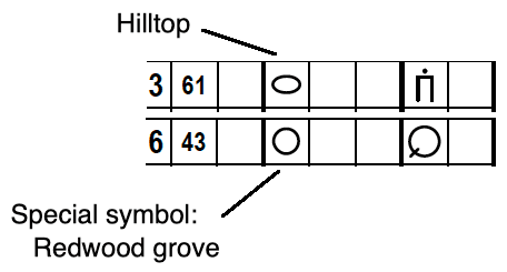
Special Clue-Sheet Symbol
For this map, it means a grove of redwood trees, which on the map looks like this:
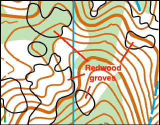
Redwoods Map Snippet
This map snippet might remind you of the Hillside of Death. Amazingly, though, here the area marked as white is in fact completely passable and the light green for the most part is passable but just slows you down some. Exception: I’ve found the interiors of redwood groves, even those mapped as white, to be slow going.
Some distinct trees are marked on the map with a large green circle and some with a small green circle. Of course, it’s a matter of judgment in terms of which symbol to use for “intermediate” size trees. The smaller green circle is also used for large bushes, which on this map means “tree-sized” bushes (I.e., ones that are a lot taller than you are). Waist-high (for instance) bushes are generally not mapped. There are also judgment calls that have to be made about trees that are near the edge of a big white patch: are such trees part of the white patch or should they be mapped as distinct? (Generally, if the canopy of a tree overlaps the canopy of one or more other trees, then it’s part of a white patch.) My point is that moving at competition speed, at some points you may be a bit uncertain about whether a particular tree is the one mapped with a big circle, or the one mapped with a little circle or just part of a white patch - just don’t let yourself get put off by that. There are plenty of other well mapped features around, vegetation and otherwise, that will let you know where you are. The map is very good, and it will be important to stay in touch with the map because there are large areas with no one distinct feature you can count on to relocate by.
There is only one fire road on the map, and it forms the southern boundary of the competition area. There really is no reason for you to go on this road, but if you are tempted, please do not go on the short segment that is marked as out-of-bounds with a string of red X's (see below).
Out-of-bounds Fire Road
There has been heavy equipment there in recent days, but I don't know whether that equipment will or won't be there during our event. Even if the equipment is not present, please don't go on that section of the road out of respect for your fellow orienteers who have dutifully (and correctly) avoided it. In any case, you'd be better off running in the terrain one to two contours above the road, as it is beautifully fast and undoubtedly closer to wherever it is that you are trying to go. Oh, and mountain bikes go flying down this road at reckless speeds.
There is only one trail in the competition area, and it is a narrow footpath. All the courses cross that trail at least twice. It is a condition of our permit that we keep a very low profile, so please, please, watch out for any non-orienteers and be very courteous if you see anyone like that.
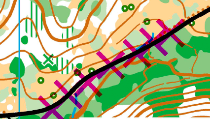
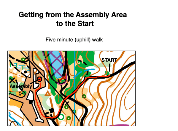
There is a five-minute walk from the Assembly Area to the Start (there's a steep uphill at the end). By park rules, we can not put out signs or even streamers, so use the map below to get to the Start.
Getting to the Start
1 We use this event to remember Greg Ehrensing, a dedicated BAOC member, who died in 2018 (at orienteering age 60). Greg particularly enjoyed this event "in his backyard" (since he lived nearby). He directed and course-set this event several times, as well as always helping out at this event and many others with whatever was needed even when he wasn't on the crew that day.