Main Courses ↑
By Matteo Guareschi
Have you ever dreamed of finding a control half a mile onto Golden Gate Bridge? No? You are in luck, it won't happen this year either.
But I do hope you'll enjoy the wonderful views this park has to offer, especially if the weather holds. The West side of the map, along the coast, is particularly beautiful if you have some time to spare.
Out-Of-Bound Areas ↑
Unfortunately, the Presidio map is, over time, more and more marred by out-of-bound areas. Fortunately, we can use them to our advantage to create interesting legs.
This is only possible when everyone is really careful about staying out of all the out-of-bound areas (which is also an important condition of our permit).
You will see these areas on the map:
- Olive green: Private lawns and other forbidden greeneries. These are not always obvious — please look carefully at the map.
- Purple cross-hatched: Areas of habitat restoration, sensitive vegetation, and construction work. Some construction areas are very recent, so I have tried to keep the courses away from them.
Underpasses ↑
Several highways and roads run over (and under) the Presidio. The roads are clearly mapped as out-of-bounds areas, but you can often run under them. These underpasses are marked on the map using the non-standard symbol of black cross-hatching.
For example, in the map segment below, two underpasses are shown as black cross-hatched breaks in the magenta, out-of-bounds cross-hatching on the highway. One underpass is under the toll plaza (at the upper left; the southwestern end of the underpass is by the [unlabeled] bus stop); the second underpass is on the narrow road southeast of the middle of the map segment.
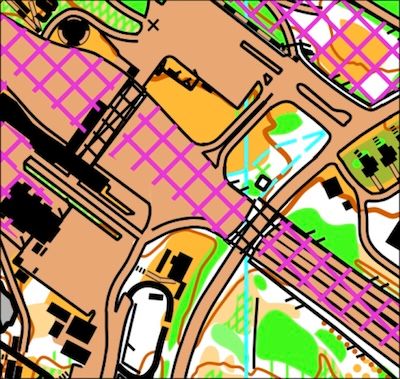
To be clear, neither the standard Crossing Point symbol (ISOM 710) nor the standard Bridge/Tunnel symbol (ISOM 512) is used in this snippet, but each of those symbols is used in conjunction with black cross-hatching elsewhere on the map, at places you will likely encounter on the courses.
Hazards ↑
Poison oak is present, but not prevalent on most of the courses — there's more on the Long course than the Short and Beginner courses.
Same for ticks. I haven't seen them, but you can bet they are lurking. Be sure to follow the recommended precautions.
You are likely to spend some time on, or crossing, a few roads. Drivers are not particularly aware of orienteers, so always pay attention, and please wear really bright colors (this is also a condition of our permit)!
Map and Courses ↑
All the maps are printed at 1:7,500, and the contour interval is 20 ft.
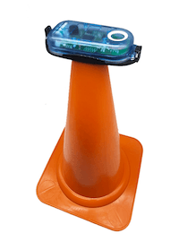
Expect to find mostly standard stake+bag controls, but a few of them will be on cones like we use for Sprint events. The picture below is an example — note that there will not be a control bag at such controls. The E-punch units are lower than usual, about 2 feet off the ground.
Here are the course details:
Course      Length    Climb  Controls
Beginner    1.9 km     60 m     11
Short       3.0 km     65 m      7
Long        5.1 km    200 m     11
Be sure to read the course comments on the event announcement page.
Also, if you are interested in doing well in the Summer Series, make sure you understand how the competition is structured, and in particular, the scoring system.
Assembly Area ↑
Like last year, we will be at Fort Winfield Scott, with both Start and Finish located just a few steps away from the Assembly Area.
Parking can be hard at times, especially if kids leagues are on. All parking in the Presidio requires payment either at a machine or through the app, and each location is very local — if you move your car, you will probably have to pay again at the new location.
This is particularly important if you are planning to run the Sprint course that Dennis Wildfogel has put together — and you should make a point of doing that!
Please do not park near the Log Cabin! Those spaces are reserved for events at the Log Cabin. Don't forget to download after running your course!
Bonus Sprint Course Setter's Notes ↑
By Dennis Wildfogel
In addition to the usual Summer Series courses, the Presidio event will offer a “bonus” course, designed to be run after you’ve done your Summer Series course of choice. This will be a Sprint course, and will take place in the Main Post area, a mile away from the Assembly Area for the other courses.
Despite our familiarity with the Main Post, the course will be navigationally and mentally challenging, while being quite easy physically. Nearly every leg has a route-choice problem to be solved. The course will be excellent practice for Sprint-O even if you don't have a great deal of energy left after your first course. Decision points come frequently — there is almost no dead running. Many people lose too much time in a Sprint by stopping to make decisions. Slow down a little and challenge yourself to have made all decisions by the time you get to the decision point!
Location and Schedule ↑
The Start and Finish for this course will be in the Main Post area. It is approximately a 5-minute drive or a 25-minute walk from Fort Scott, where the regular Summer Series courses start and finish. See below for directions.
Starts will be available from 11:15 AM to 1:30 PM, with course closure at 2:00 PM (meaning you must return to the Finish by 2 PM even if you haven’t completed the course).
After you reach the Finish, report to the person working at the Start (probably me) so that we know you are done. To download, you must return to Fort Scott.
The Course ↑
The Sprint course is 1.8 km long, measured in straight lines, and about 50% longer than that along the optimal route. Climb is only 15 m in total. There are 16 controls.
All the E-punch units will use bright-orange traffic cones as stands. The picture above is an example — note that there will not be a control bag at these controls. The E-punch units are lower than usual, about 2 feet off the ground.
Map Notes ↑
Do not enter any areas mapped as olive green. These can look very passable, but you must be disciplined enough to notice these areas, and not go through them (or jump over them, or reach across them to punch a control). Doing so could lead to us losing the ability to ever again get a permit to orienteer in this lovely place. It also would be extremely unfair to the other orienteers who properly go around such an area instead of going across it. Finally, you’ll be cheating yourself, because the whole point of this Bonus Sprint is to give you practice in noticing the fine details on the map and planning your routes accordingly. These green areas are, in this case, key to creating route choice, which is the main point of this exercise. If I sound pretty cranky about this, well, I have often seen people who should know better go through olive green areas or go through unmapped holes in fences mapped as uncrossable — don’t be one of those people, OK?
The accompanying photo shows an actual example. Could you physically go aross that area of new plants? Of course. Could you do so without damaging any of the young plants? Quite possibly. Should you go through it? NO!! Please pay attention to this.

Note that the only areas mapped with any shade of green in the Sprint course area are either olive green or very-dark green. The latter also may not be crossed or gone through, so the algorithm is pretty simple: if you see any green area at all, do NOT go through it, no matter how inviting it might look.
There are numerous benches in the competition area which are not mapped; same for light poles.
There are no multilevel situations on this course.
Potential Hazards ↑
As with many major European orienteering events, the course goes through areas with many pedestrians. This adds to the excitement, but please try really hard not to startle anyone, nor knock anyone over!
You will cross several roads and parking areas. None of them have fast moving vehicles, but they do have moving vehicles, so take care when you cross. You will always have a good line of sight.
The toilets we usually use in this area, at the Transportation Center and near the food trucks, are in the competition area and may not be accessed prior to going out on your course. Consider using the facilities at Fort Scott before you head for the Sprint. If you’re really desperate, check with whoever is working at the Start — they might have a solution for you.
Parking ↑
Parking at the Presidio is now by zone, and the zones are very small. Bottom line: you’ll have to pay for parking again if you drive to the Sprint. Keep that in mind when you’re figuring out how much time to pay for when you first park at Fort Scott. Detailed info about parking can be found here.
Please park only in the areas indicated on the Directions map (see the next section).
Directions ↑
Driving Directions ↑
You must follow the route shown by a blue line on the map at the right so as to avoid entering the competition area before you go out on the course. That is, you must avoid entering the area overlaid with dark-blue cross-hatching. (Click on the small map to see a large image. If you download that image, you can print it on 8.5"x14" or 11"x17" paper.)
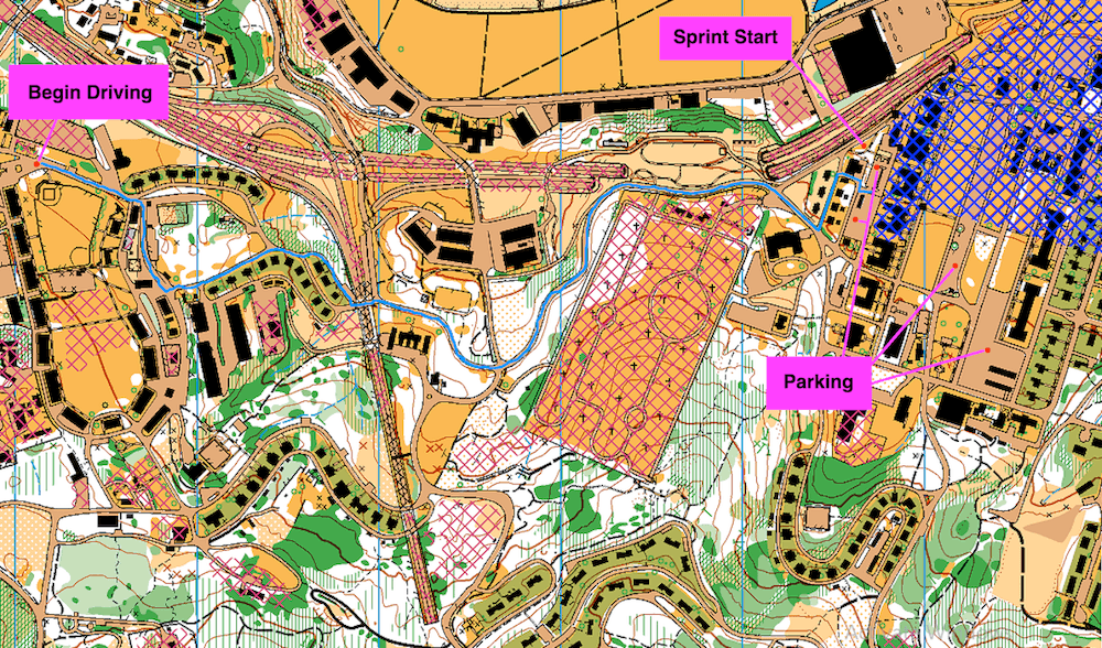
Follow the steps from Google Maps (which estimates the time at 6 minutes).
If that parking lot is full, you can park in the other lots indicated on the map image above:
- At coordinates 37.8006,-122.4600
- At coordinates 37.7997,-122.4584 (but only in the first third of the lot, entering from Sheridan Ave.)
- At coordinates 37.7984,-122.4583
Walking Route to Sprint ↑
The route shown by a blue line on the map at the right suggests how to walk to the Sprint Start (coordinates 37.8016,-122.4596) while avoiding heavy traffic (and climb). As with the driving directions above, make sure you do not enter the competition area before you go out on the course. That is, you must avoid entering the area overlaid with dark-blue cross-hatching.
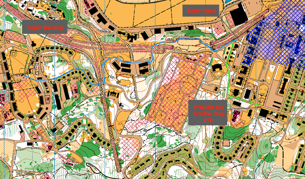
Here's a Google Map for the walk. It estimates the time at 22 minutes for the 1.0-mile walk.
You could use the free Presidio GO shuttle instead of walking, but if you take the shuttle toward the Start, make sure you get off at the Officer's Club stop, not at the Transit Center (which is in the embargo area). Shuttle stop #19 (The Officer's Club) is shown on the map above. From there, follow the green line on the map to the Sprint Start. Note, however, that the shuttle route from near Fort Scott toward the Start will take you on a long, scenic tour of the Presidio. The shuttle stops nearest Fort Scott are "Coastal Trail" (Washington Blvd at Kobbe Ave; 37.7992,-122.4778) and "Rob Hill Campground" (Washington Blvd at Harrison Blvd; 37.7975,-122.4766)
Taking the shuttle for the uphill return to Fort Scott is a viable option, since that's short the direction around the shuttle's loop. You can get on the shuttle at the Transit Center, which is near the Sprint Start/Finish, and get off at the "Rob Hill Campground" or "Coastal Trail" stop (see the paragraph above for those locations).
With Gratitude ↑
Thanks to George Minarik, who designed a preliminary version of the course. Unfortunately, we learned of restrictions imposed by the Presidio only after George did his design, and so the entire course had to be redesigned. Nevertheless, I am still using the assembly area that George picked out, which was a great help to me when I designed the course that you will run. Any shortcomings of the course are entirely my responsibility. I’d also like to thank Gavin Wyatt-Mair, course setter for the NRE Sprint at the Presidio last year. Among other things, Gavin went to the BAOC locker and got the orange traffic cones that are perfect for an urban orienteering course like this one. Thanks also to Misha Kreslavsky, who made a bunch of map corrections I noticed, to Sarah Williams, who made labels for the cones, asking that they not be disturbed, and to Matteo Guareschi, Course Setter for all the other courses at this event, who delivered to me the E-punch units I need. And, as always, thanks to Chuck Spalding for working on these webpages.